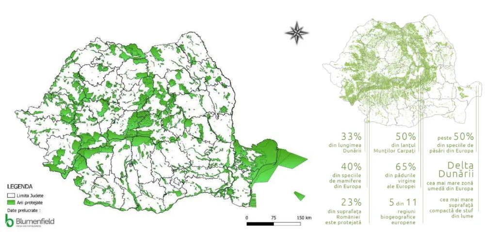
Digitising the boundaries of protected natural areas of national, European and international interest cost 9 million euros and was paid for with European funds, with the results accepted and approved through:
- Emergency Ordinance No. 49/2016 amending Law No. 5/2000 approving the National Spatial Plan – Section III – protected areas.
- Law No. 60/2017 approving Emergency Ordinance No. 49/2016 amending Law No. 5/2000 approving the National Spatial Plan – Section III – protected areas.
The Ministry of the Environment has still not published the project’s results, leading to the degradation of protected areas whose boundaries some authorities and investors interpret as they please.
“We took the initiative to publish the INSPIRE results because the Ministry of the Environment is doing nothing and is thereby complicit in the siphoning off of 9 million euros in European funds and the degradation of protected natural areas. We call on the minister to publish this information of public interest on the ministry’s website as soon as possible too,” said Gabriel Păun, president of Agent Green.
Download the boundaries of Romania’s protected areas now
Project information
Name: “Creating spatial datasets in accordance with INSPIRE technical specifications for protected natural areas, including Natura 2000 sites, with a view to optimising the facilities for their management”
Beneficiary: Ministry of the Environment and Climate Change, Biodiversity Directorate.
Coordinator: Diana Mihaela Cocai – adviser, Biodiversity Directorate, Ministry of the Environment and Climate Change.
Service provider: The consortium comprising S.C. Open GOV S.R.L. (consortium leader), S.C. ROMSYS S.R.L. (second consortium member) and Teamnet International (supporting third party).
Period: 1 February 2013 – 30 June 2015
Budget: 40,679,022 lei (including VAT).
Co-financed: by the European Regional Development Fund through the Sectoral Operational Programme Environment 2007-2013”
Protected natural area: “A clearly defined geographical space, recognised, dedicated and managed, through legal or other effective means, to achieve the long-term conservation of nature, together with associated ecosystem services and cultural values.”
A protected area is established in a terrestrial, aquatic and/or underground zone containing wild plant and animal species, biogeographical, landscape, geological, palaeontological, speleological or other elements and formations of particular ecological, scientific or cultural value.
In Romania, a protected natural area has a special protection and conservation regime (although protection is not actually ensured), established under legal provisions and partially incorporating the categories of the International Union for Conservation of Nature (IUCN) or other types of protected areas.
| Category | IUCN | Romania |
|---|---|---|
| Ia / I | Strict nature reserve | Scientific reserve |
| Ib | Wilderness area | – |
| II | National park | National park |
| III | Natural monument | Natural monument |
| IV | Area with active habitat/species management | Nature reserve |
| V | Protected landscape/seascape | Nature park |
| VI | Protected area with sustainable use of natural resources | – |
Categories of protected areas by importance
A. Of local interest, designated by the Local Council
- Scientific reserve
- National park
- Natural monument
- Nature reserve
- Nature park
B. Of county interest, designated by the County Council:
- Scientific reserve
- National park
- Natural monument
- Nature reserve
- Nature park
C. Of national interest, designated by Parliament, the Government or a ministry:
- Scientific reserve
- National park
- Natural monument
- Nature reserve
- Nature park
D. Of European interest, designated by the European Commission at the initiative of the Romanian Government (Natura 2000 sites):
- Site of Community Importance
- Special Protection Area for birds
E. Of international interest, designated by UNESCO:
- Biosphere reserve
- Wetland of international importance
- Natural site of universal natural heritage
- Geopark
Download the boundaries of Romania’s protected areas now
| File name (shp / kmz) | Corresponding protected-area category | |
|---|---|---|
| 1 | Strict_Nature_Reserve | Scientific reserve |
| 2 | National_Parks | National park |
| 3 | Natural_Monuments | Natural monument |
| 4 | Habitat_sp_management | Nature reserve |
| 5 | Nature_Parks | Nature park |
| 6 | Biosphere_Reserves | Biosphere reserve |
| 7 | Ramsar_sites | Ramsar site |
| 8 | SCI | Site of Community Importance |
| 9 | Special_protection_areas | Special Protection Area for birds |
INSPIRE
In Europe, a major recent development was the entry into force of the INSPIRE Directive, establishing an infrastructure for spatial information in Europe to support Community environmental policies and policies or activities that may affect the environment. On 14 March 2007, the European Parliament and the Council adopted Directive 2007/2/EC establishing an Infrastructure for Spatial Information in the European Community (INSPIRE), published in the Official Journal on 25 April 2007.
The INSPIRE Directive aims to create a European Union spatial data infrastructure. This will allow environmental spatial information to be shared among public-sector organisations and facilitate public access to spatial information in Europe.
INSPIRE is based on infrastructures for spatial information established and operated by the 27 Member States of the European Union. The Directive covers 34 spatial data themes needed for environmental applications, with key components specified through technical implementing rules. To ensure that Member States’ spatial data infrastructures are compatible and usable in a Community and cross-border context, the Directive requires Implementing Rules (IR) to be adopted in several specific areas: metadata, data specifications, network services, data and service sharing, monitoring and reporting.
The INSPIRE vision envisages a geospatial information infrastructure providing a wide range of integrated geospatial information services. These enable users to identify and access geographical information from participating data producers throughout Europe in an interoperable way for formulating, implementing, monitoring and evaluating Community policies that provide public information.
INSPIRE principles
- Data should be collected only once and kept where they can be maintained most effectively;
- It must be possible to combine spatial information from different sources across Europe and share it with many users and applications;
- It should be possible to share information collected at one level/scale with all levels/scales: detailed for thorough investigations, general for strategic purposes;
- Geographical information needed for good management at all levels must be available in a readable and transparent form;
- Easy discovery of the geographical information available, how it can meet a particular need and under what conditions it can be obtained and used.
Transposition in Romania
The INSPIRE Directive was transposed into national legislation through republished Government Ordinance 4/2010 establishing the National Infrastructure for Spatial Information (INIS). In addition, Government Ordinance 4/2010 defines the general legal framework needed to establish INIS, coordinated by the Council of the National Infrastructure for Spatial Information. The dedicated INSPIRE geoportal is the solution for sharing and distributing spatial datasets and their associated web services. Within INSPIRE, an open and transparent process for stakeholder participation was established. These stakeholders are part of the INIS Council, which comprises 23 organisations responsible for coordinating the development of the spatial information infrastructure.
Within INSPIRE, the solution adopted by Romania for distributing and sharing spatial datasets and their associated web services is Romania’s INIS Geoportal. The application is designed to facilitate the discovery and exchange of geospatial data resources within a broad user community, providing means to search for and discover spatial datasets and web services under the INSPIRE Directive. Romania’s INIS Geoportal is a relevant gateway, updated with quality geographical information, and has real potential to improve decision-making and operations at all national levels involved in activities with a direct or indirect impact on the environment.